Geocode by Awesome Table 69 CRX for Google Sheets
A Free Productivity Add-on
Published By Awesome Gapps
Geocode by Awesome Table (cnhboknahecjdnlkjnlodacdjelippfg): Geocode is a tool that helps you get latitudes & longitudes from addresses in a Google Sheet to display them on a map you can share.... Read More > or Download Now >
Geocode by Awesome Table for Google Sheets
Tech Specs
- • Type: Google Sheets Add-on
- • Latest Version: 69
- • Price: Freeware
- • Offline: No
- • Developer: Awesome Gapps
User Reviews

- • Rating Average
- 4.1 out of 5
- • Rating Users
- 284
Download Count
- • Total Downloads
- 29
- • Current Version Downloads
- 29
- • Updated: February 5, 2019
Geocode by Awesome Table is a free Productivity Add-on for Google Sheets. You could download the latest version crx file or old version crx files and install it.
More About Geocode by Awesome Table
Geocode is a map tool that helps you get latitudes and longitudes from addresses in a Google Sheet and display them on a Google map you can share.
Easily get geographic data
Addresses are converted into Maps coordinates: longitudes and latitudes. Geocode uses Google's services to retrieve these data and is optimized for address recognition thanks to a built-in error management system: if Google doesn't recognize an address, Geocode can perform a broader research, making sure you get a result for each row of your spreadsheet. And then we display all your data on a map.
How does it work?
Create a spreadsheet (or reuse one of your existing ones)
Add physical addresses and other info
Use the spreadsheet menu Add-on > Geocode
Indicate the column containing your addresses
Click on the button to start the geocoding
That’s all! Once the geocoding is done, you will see two more columns in your spreadsheet (for latitude and longitude data) and a link to the Maps view created.
The Google Maps view is powered by Awesome Table
All rows of your spreadsheet are displayed as markers on the map
If you have too many markers we do some automatic clustering to improve the display
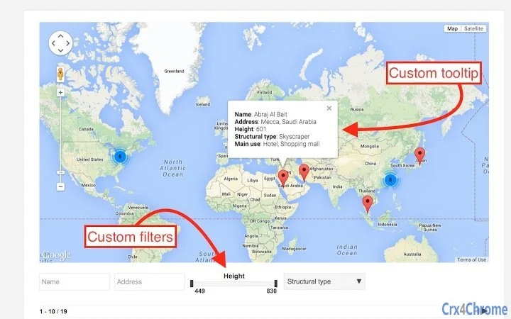
You can filter the data displayed on the map based on the data in your spreadsheet (we have filters for every type of data - lists, dates, numbers,...)
A table is displayed (and can be hidden) below the map, listing all information from your spreadsheet (if you click on a specific row in this table, the Map is automatically centered on the location linked to this row)
On each marker displayed on the map, a tool-tip is available (pop-up with additional info) and you can customize this tool-tip to display the info you want (you can even add some HTML, to add links or images)
Easily get geographic data
Addresses are converted into Maps coordinates: longitudes and latitudes. Geocode uses Google's services to retrieve these data and is optimized for address recognition thanks to a built-in error management system: if Google doesn't recognize an address, Geocode can perform a broader research, making sure you get a result for each row of your spreadsheet. And then we display all your data on a map.
How does it work?
Create a spreadsheet (or reuse one of your existing ones)
Add physical addresses and other info
Use the spreadsheet menu Add-on > Geocode
Indicate the column containing your addresses
Click on the button to start the geocoding
That’s all! Once the geocoding is done, you will see two more columns in your spreadsheet (for latitude and longitude data) and a link to the Maps view created.
The Google Maps view is powered by Awesome Table
All rows of your spreadsheet are displayed as markers on the map
If you have too many markers we do some automatic clustering to improve the display
You can filter the data displayed on the map based on the data in your spreadsheet (we have filters for every type of data - lists, dates, numbers,...)
A table is displayed (and can be hidden) below the map, listing all information from your spreadsheet (if you click on a specific row in this table, the Map is automatically centered on the location linked to this row)
On each marker displayed on the map, a tool-tip is available (pop-up with additional info) and you can customize this tool-tip to display the info you want (you can even add some HTML, to add links or images)
![]()